|
Carboniferous limestone cliffs
Sheep pasture
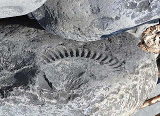
Ammonite impression in limestone boulder
|
Parking
at the far south of Ogmore-by-Sea, we walked 100m back down to the coast path
and continued east, the whole day along the top of fairly low cliffs, the
plants unremarkable with agricultural land bordering us inland – sheep
pasture and arable. The shore platform
was of Carboniferous limestone (e.g. Black Rocks), initially with Recent
blown-sand cliffs above, latterly steeper with cliffs also of limestone. We came down into Dunraven Bay, but the tide was
high. There is a Heritage Centre for
the Glamorgan
Coast,
where we bought a geology of the area for future reference. There were also well-timed toilets for
relieving over-indulgence in breakfast coffee. A small artificial pond contained Curled
Pondweed. This “Heritage Coast” is quite
scenic, although no Pembrokeshire or Gower.
Various paths led up the slope opposite, where there are stone remains
of a fort on the headland of Trwyn Y Witch or Witches' Point, composed of
Liassic Sutton Stone overlaying the Carboniferous limestone. A series of descents-and-rises at streams
entering the sea followed at intervals, but none too exacting. From Cwm Mawr to Cwm Bach, Blue Lias cliffs
replace those of the Carboniferous limestone, as briefly happens also at Cwm
Nash. They are distinguished by their
pale colour compared to the dark Carboniferous limestones (as at Black
Rocks). At field edges Musk Thistle
was common, just coming into flower, while Woolly Thistles were identifiable
from their distinctive leaf-rosettes.
Occasionally Choughs were seen and heard. The next accessible cove was at Nash Point,
where we descended into the cove from the coast path, both to take some lunch
and to explore the beach. Sheer cliffs
of Blue Lias rise high here, composed of conspicuous bands of sandy-coloured
limestones interbedded with softer shales, which weather to produce regular
rock falls. These had affected the
coast path coming here, as it is continuously having to be re-routed further
from the crumbling edge. The top of
the beach is composed of rough or sea-worn limestone boulders, many with
fossils of shells and ammonites. Below
these is a flat shelf of limestone that makes very easy walking. Herring Gulls and Jackdaws nested on the
cliffs, which exhibit frequent faulting.
The jackdaws were omnipresent to sight and sound today from our start
to the very end. Much of the way,
too, the cliffs were notable for
abundant Wild Cabbage. As the day
warmed up with continuous sunshine, butterflies became increasingly
prevalent, especially (no doubt as a result of the cabbage) the Whites (Large
and Green-veined). Just after Nash
Point were two lighthouses and a foghorn, now disused except for announcing
weddings! The cliffs now started to
become much lower. At St Donat’s Bay
there was a concrete walkway at the front but there was no access to the
castle and its grounds, now a college.
There were clumps of stinking iris here. The next bay, Tresilian, was notable for
the large pebbles we had to negotiate to cross the beach, made even more
difficult by a colony of Japanese Knotweed!
The cliffs here have a number of sea-caves (e.g. Reynolds Cave), whose ceilings
are protected by a particularly hard band of limestone. After Tresilian a projection of sand and
rocks at shore level replaced the usual flat rock shelf and demarcated the
cove below Llantwit Major. Celebratory
ice-cream in hand, we left the coast path here to walk 1½ miles up a very
wide green valley which was white on the side-slopes from flowering Hawthorn,
to the bus station and transport back to Ogmore.
|
Cliffs from Cwm Mawr to Cwm Bach (blue lias)
Stinking iris
|


No comments:
Post a Comment